
ReDoCO₂ – Reducing and Documenting CO₂ Emissions from Peatlands
A completed innovation project delivering field‑scale, high‑resolution mapping of peat, carbon stocks, and CO₂ reduction potential.
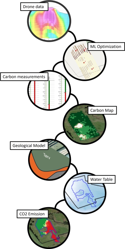
The ReDoCO₂ project has successfully developed and validated new geophysical and data‑driven methods for mapping peatlands and their carbon content – from national scale down to individual fields.
ReDoCO₂ enables accurate, 3D‑based carbon stock assessments and decision‑ready maps for peatland management and climate action.
Key results
What ReDoCO₂ delivered
High‑resolution peat and carbon stock mapping– Spatial resolution improved from 100 m to 10 m– Accurate estimation of peat thickness and full carbon stock, not limited to the top 30 cm
Validated airborne and drone‑based geophysics– Compact airborne TEM system optimized for peatlands– Successful use of gamma‑ray sensing for peat delineation– Operational, scalable workflows suited for real‑world deployment
Advanced machine learning and 3D modelling– National models upgraded to 10 m resolution using >230 covariates– Local, field‑scale models enabling high precision under sparse ground truth
– Integrated 2D and 3D models using GeoScene3D
Actionable climate scenarios– Estimation of current CO₂ emissions
– Scenario modelling for rewetting and water‑level changes
– Quantified CO₂ reduction potential to support decision‑making
Why it matters
Supporting climate policy and land management
Denmark was the first country to introduce a CO₂ tax on peatlands. This created an urgent need for field‑scale, locally accurate maps, as existing national products are not sufficient for taxation, planning, or compensation schemes.
ReDoCO₂ addresses this gap by delivering:
- Field‑level accuracy suitable for regulation and taxation
- Transparent, data‑driven documentation of carbon stocks
- A methodology recognised by authorities as a future alternative to current mapping standards
From project to practice
Ready for use – from pilots to national scale
The ReDoCO₂ project is completed (2020–2025), and the results are:
- Scientifically validated
- Technically mature
- Ready for commercial and regulatory use
The developed methods are scalable:
- From: Individual sites and farms
- To: Large regional and national peatland mapping campaigns
Partners & funding
Project partners
I‑GIS A/S · SkyTEM A/S · Aarhus University · Aalborg University · Region Midtjylland
Funded by
Innovationsfonden (Denmark)
Contact:
Contact Project Coordinator:
I-GIS A.S., Voldbjergvej 14A, 1.st floor, DK-8240 Risskov
Email: npj@i-gis.dk